


Planning a BWCA trip shouldn’t be rushed… well sometimes maybe it should. But the one I am planning doesn’t need to be.
I was online doing some extra research on the area of lakes my buddy and I were planning on camping on. I like to have a good idea which campsites have good reviews, and what the portages between the lakes are like. Anyway, I found out that the area we were planning on camping in got wiped out a few years ago by a massive forest fire.
Ideally the area we were looking at is devoid of big trees. They all got burned down. Small trees over the past several years have been coming up, but not enough to provide comfortable shade around a campsite, or enough to throw up a couple camping hammocks.

Back in 2011 a lightning strike 13 miles east of Ely, MN, in the Pagami Creek area of the Boundary Waters, created a massive wildfire that burned towards the east and south east destroying over 92,000 acres of wilderness. Smoke from the fire drifted as far as the Ukraine!
The Forest Service evacuated a large area of the BWCA and closed down 116 campsites for an extended period of time. It was a big deal. I remember back in 2011 seeing the smoke haze in the sky from where I lived several hours south.
What does this mean for my trip?
We Are Changing Our Camping Location Plans!
I have to admit I am curious to see the after affects from the forest fire, but I don’t want to camp among the burned out areas. My buddy and I want trees in and around the lakes we are going to fish and camp on. I am pretty much determined to use my hammock to sleep in during the trip, and need some sturdy trees to set that thing up. Also, shade can be important when that sun is high above and beating down on you.
So after much discussion we decided to look for a new entry point and an all new area to head off to and do a base camp from.
There have been a couple sizable forest fires in the BWCA over the recent years, so in order to avoid such areas for future planning I turned to Google Earth! Google Earth gives me a great top down view of the BWCA, and I can exactly where the fires have been and how much they have burned.

You can download Google Earth here.
Back To The Maps – National Geographic BWCA Maps!
I don’t have much in the way of plans for this coming weekend. Might be heading up to my cabin for a few nights. When I’m there I plan on pouring over my BWCA maps once again. Back to square one in finding a place we want to camp.
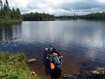
Nothing has changed. We still want to portage in a few times and set up a base camp on a nice cozy site. Do some fishing, some exploring in the woods, napping, reading, journaling, swimming…
I have my eyes on entry point #64 at the moment. I’ll take a closer look at the area in the next few days and through the weekend.
I also have started updating some of the camping kit I have that is old. I have a few new kit items coming that I plan on sharing with everybody here and doing some field tests.
TD