


With over a million acres of beautiful forest jam packed with thousands of pristine lakes, rivers and streams, planning a trip to the boundary waters of Minnesota requires maps. Highly detailed maps. In particular Boundary Waters Canoe Area maps.
A good map is needed for two reason: 1) Early trip and route planning, 2) Navigating once you are there.
When making such a trip as I am planning you need to know how to read a map, use a compass, and navigate with both dead reckoning as well as map plotting. A modern GPS device can make things supper easy and would be beneficial on such a trip into the wilds – and to be honest I’ll probably have one along.
First and foremost however I plan on doing things old school with a map and compass.
Luckily there are many great resources out there for planning a canoe camping vacation. Of course in this day and age you can go online and figure out a lot of your pre-trip planning, but I like having maps in hand. I enjoy unfolding a map and studying it, especially in preparation for an outdoor adventure!
What Kind Of Boundary Waters Trip Do You Want To Take?
Some people like to paddle and portage to see as many lakes as they can during their vacation. Other people like to setup a base-camp and not push themselves too hard.
I’ve been on both kind of trips. Personally I like to create a base-camp and relax… fish the lake or surrounding lakes… do some hiking… lay around the campsite reading a some pulp-trash fiction… take a nap… go for a swim… You get the idea.
There is nothing wrong with breaking and setting up camp on a new lake each day you are there. To each their own. The Boundary Waters Canoe Area can handle it!
Whatever type of trip you decide to plan, you are going to need some Boundary Waters Canoe Area (BWCA) maps. You need to know where you are entering the BWCA, where you are going once there, and how you are going to get out.
There are a lot of great maps that show the lakes, river, streams, rapids, portages, and land contours, and they are highly beneficial to have on hand during a wilderness vacation.
Boundary Waters Canoe Area Maps
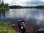
I have one trip that is for sure going to happen next year in 2018 into the BWCA. I am going on this trip with my lifelong buddy, Jim. Others may tag along, but as of right now Jim and I are the only people for sure going on the trip. The past few weeks we have chatted off and on about what kind of trip into the BWCA we want to do. Both of us agreed to finding a good site for a base-camp and doing day excursions around the area.
The idea of hanging around a camp we will call home for five or six days sounded appealing to both of us. We plan to do some fishing for walleyes and possible lake trout, work on some camping and bushcraft skills, maybe do some light hiking, and just relax while surrounded by sexy Mother Nature.
With the type of trip decided upon we needed to figure out just where in the BWCA we wanted to go. I’ve been on a few trips over the years to the area and wanted to go see something new, where this would be Jim’s first visit there. So Jim is leaving it up to me, for the most part, to decide upon a general area for our wilderness vacation
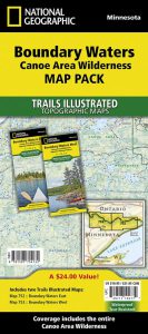
This is where I went online to Amazon and decided to order myself some updated National Geographic BWCA Maps. These things are great. There are a few places you can go to get different types of maps showing various areas of the BWCA. But the National Geographic maps are in my opinion the best.
These maps are big, have great detail, and have all of the BWCA on two different maps; the East and West areas of the BWCA. they are waterproof, tear resistant, in color, fold up easily, have a scale of 1″ to 1.1 miles, show campsites and portages, and are super easy to scan and print off sections that pertain to my trip.
I’ve had these maps before, but they do get updated regularly when campsites and portages change. So buying new maps every couple years if you are a regular vacationer in the BWCA is a good idea.
These Boundary Waters Canoe Area maps also have something none of other maps (Voyager maps, McKenzie Maps etc…) have, and that is Universal Transverse Mercator (UTM) coordinates. UTM coordinates come in handy to enable precise locations fixes with a GPS unit.
Planning Where We Want To Go In The BWCA
Here is the where the pre-trip planning gets exciting and frustrating all rolled into one lump! As soon as my maps arrived I wasted no time diving in trying to decide a good place for our base-camp.
Jim and I both agreed we wanted a lake that would hopefully be quieter (less people, less canoe traffic). We weren’t’ afraid of doing some portages to get there, but wanted to avoid a route that would have to many long portages. A bunch of smaller portages and maybe a long one was okay, but not too many long ones.
Finding such a place should be easy, especially for the time of year we planned on going, which will be at a time when the BWCA would start to quiet down and see less vacationers. With school starting for most kids around when our trip is set to begin, we suspected that not many families doing the summer vacation thing would be about.
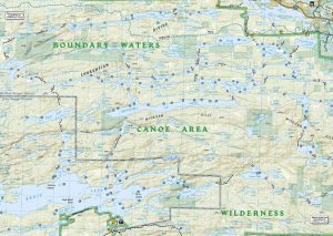
A very popular entry point into the BWCA is entry point #30, just fifteen or so miles East of the north-woods town of Ely. As I write this 18 people or groups with a permit are allowed into the BWCA through entry #30 per day. It’s pretty busy, usually, and is the main entry point for the ‘numbered’ lakes in the Boundary Waters (Lake One, Lake Two, Lake Three, Lake Four..etc…)
Mostly the permit holders that come in through this entry point head down through the numbered lakes as they go east towards other lakes like Lake Hudson and Lake Insula. I decided Jim and I would head South by South-West to some smaller and reportedly quieter lakes such as Pietro and Gull Lake.
Both Pietro and Gull would be just a handful of portages into the BWCA, are smaller, and should offer some quieter solitude that we both are looking for.
Online Resources To Help You Plan A Boundary Waters Canoe Area Trip
There are some great online resources that I have been using to assist in planning my 2018 BWCA trip. The site below provides great feedback by people who have actually vacationed on the lakes. You can get some good details regarding portages and campsites, which I like to review in particular.
Information on the campsites is of particular interest to me, as I like the idea of knowing what Jim and I might come to expect when we pull up to a potential site.
I know… I know, some of you will think that takes the ‘adventurous spirit’ out of things… and maybe you are correct. But I tell ya what, I’ve been there in the past when a major storm is coming in and you have to scramble to find a good site to put ashore and setup camp fast. It’s nice to know what some camps site offer ahead of time.
You can find some basic online maps and various other resources to help you plan a BWCA trip on the following site: BWCA.COM.
Boundary Waters Canoe Area Maps – Wrapping It Up!
If you are thinking of planning a trip to the BWCA get yourself some maps. The National Geographic Boundary Waters Canoe Area maps are the best ones out there. Most updated, best information, and fantastic quality.
Sure, you can do a lot of your planning using online resources, but having good maps in hand are worth it. Spreading one of these maps out on your table really is an eye opener when you can see all the lakes you can travel to. They fold easy, scan easy, and you can make quick prints for everybody in your group.
Get your National Graphic BWCA maps here!
If you have any past trip experiences or lakes you recommend please share them below!
TD
Hi,
Sorry you had troubles posting but thanks for reading and the quick comment!
2019 is going to be a great year for canoe tripping.